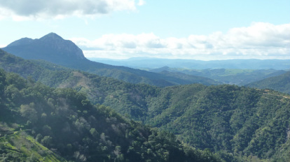
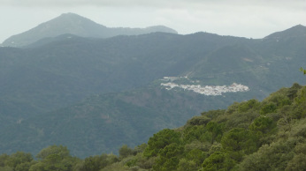
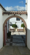
View from Banu Rabbah Hotel Banarraba
Genalguacil to Benarraba
This leg of the journey descends steeply into the Genal Valley. On this track we are following in the footsteps of generations of mules, muleteers and pedestrians, such as the postman, who had a daily round between villages of 50 kms. I really find this hard to believe I have trouble with 20. They must have been super fit! Fortunately this is quite a short walk at 6 kms but the distance belies the effort as the path requires concentration over loose rock and pebbles, steep, winding and narrow. Mountain bike riders come hurtling down on us from around a rock face and we only just have the time, and the room, to squeeze out of the way. We take a much needed break at the bottom sitting on the bank of the Genal River ready for the ascent up to the village.
Benarraba is similar in size to the previous two villages we have visited and in the same traditional whitewashed appearance. Apparently all houses are required to be painted white and they are re-whitewashed every year. The village name, as other villages of the region, dates back to the Berber tribes who settled them, ‘Ben’ meaning son of, or tribe, in Arabic.
Our accommodation tonight is the Banu Rabbah Hotel. This small two star hotel is a little paradise with views directly towards the valley and mountains. As the night air cooled we sit in front of the log fire in the lobby and enjoy a well- earned bottle of Spanish wine and chat to the friendly manager. The hotel/restaurant provides us with a hearty meal, the highlight being the entrée featuring an artistic arrangement of oranges and avocado cut thinly and dressed with orange juice, mustard seeds and olive oil. I try the local chestnuts for dessert which had been whipped into a mousse like consistency and served with cream.
Benarraba to Algatocin, Benalauria and Benadalid
It is warming up, we shed our jackets yesterday and today we are walking in long sleeve t-shirts. The winter sun shines through a topaz blue sky with only small puffs of cloud to mar the evenness. The outlook is clear through to the Rock of Gibraltar and thence to Morocco. These mountains and villages have so much fascinating history and evidence of the constant struggle between the Moors (Moslems) and the Spanish (Catholic) populations as well as the Roman influences of roads, amphitheatres and castles.
The bird song is more evident today, this area is a north-south passage for annual bird migration; we have been told to look out for griffin vultures and falcons soaring overhead. The forest is the domicile of deer, including the rare ibex, wild pigs and domestic black pigs, Egyptian mongoose and horses among others but we are walking at the wrong time of the day to sight these cautious creatures that are more evident at dusk or dawn.
We meet a few older members of the village taking a walk. There is much more activity now the sun is shining. Villagers are working in their vegetable plots. A donkey is pulling a hand plough, making furrows in the rich brown soil ready for the spring planting. It looks like a picture from medieval times. One old man, his aged limbs supported by a wooden walking stick, ambles slowly from his gate, his bright blue eyes taking in our map which we are examining at the junction of two separate paths leading in different directions. He greets us and speaks in the local dialect indicating with his arms the different paths. We show him our map but he waves his arms and shrugs his shoulders and then indicates the path on the right and we understand when he pronounces ‘Algotocin’. We thank him and wave and he totters off in the other direction where we surmise he is having lunch. The writer Vincente Espinel (1551-1641) wrote that ‘the longevity of the Rondenos was legendary’, and this still seems to apply today in Ronda and surrounding villages.
As lunchtime approached and just before we make the final ascent to the village of Algotocin, a friendly young Dutchman, working on a house in the sunshine, stops us with a greeting. He tells us about his decision to bring his family to come and live in this part of Spain, he is a traveller like us and has experienced life in many countries, learning the language and living as a local in the community. He gives us a bag of mandarins from his tree and waves us on our way.
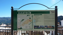
It is nearly 2pm when we arrive at our lunch stop at a local restaurant in Algatocin, we are ravenous and my calf muscles are screaming out for a rest.
It is warming up, we shed our jackets yesterday and today we are walking in long sleeve t-shirts. The winter sun shines through a topaz blue sky with only small puffs of cloud to mar the evenness. The outlook is clear through to the Rock of Gibraltar and thence to Morocco. These mountains and villages have so much fascinating history and evidence of the constant struggle between the Moors (Moslems) and the Spanish (Catholic) populations as well as the Roman influences of roads, amphitheatres and castles.
The bird song is more evident today, this area is a north-south passage for annual bird migration; we have been told to look out for griffin vultures and falcons soaring overhead. The forest is the domicile of deer, including the rare ibex, wild pigs and domestic black pigs, Egyptian mongoose and horses among others but we are walking at the wrong time of the day to sight these cautious creatures that are more evident at dusk or dawn.
We meet a few older members of the village taking a walk. There is much more activity now the sun is shining. Villagers are working in their vegetable plots. A donkey is pulling a hand plough, making furrows in the rich brown soil ready for the spring planting. It looks like a picture from medieval times. One old man, his aged limbs supported by a wooden walking stick, ambles slowly from his gate, his bright blue eyes taking in our map which we are examining at the junction of two separate paths leading in different directions. He greets us and speaks in the local dialect indicating with his arms the different paths. We show him our map but he waves his arms and shrugs his shoulders and then indicates the path on the right and we understand when he pronounces ‘Algotocin’. We thank him and wave and he totters off in the other direction where we surmise he is having lunch. The writer Vincente Espinel (1551-1641) wrote that ‘the longevity of the Rondenos was legendary’, and this still seems to apply today in Ronda and surrounding villages.
As lunchtime approached and just before we make the final ascent to the village of Algotocin, a friendly young Dutchman, working on a house in the sunshine, stops us with a greeting. He tells us about his decision to bring his family to come and live in this part of Spain, he is a traveller like us and has experienced life in many countries, learning the language and living as a local in the community. He gives us a bag of mandarins from his tree and waves us on our way.
It is nearly 2pm when we arrive at our lunch stop at a local restaurant in Algatocin, we are ravenous and my calf muscles are screaming out for a rest.
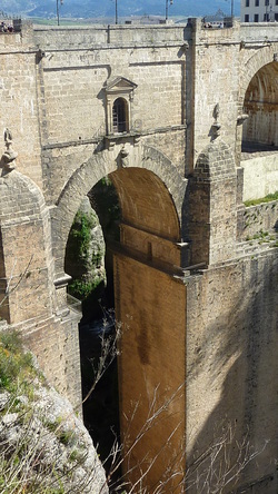
Ronda Puente Nuevo
Ronda
We have a day off today to do some sightseeing in the City of Ronda. Our route guide directs us to the local bus, but as that leaves the village at 8.10 am we decide to arrange a local taxi to take us later so we can indulge in a well-earned rest.
Ronda is situated on the Guadelvin River, which divides it in two, running through the steep 100 metre El Tajo Canyon upon which the City perches. The view from the walls, down onto the surrounding plains, are quite sensational and it is easy to imagine from this well- fortified position being able to defend the city from invading hordes. We walk along the battlements until we come to the Puente Nuevo (New Bridge), one of three bridges which span the gorge and join the City, the bridge, built in 1751 and completed in 1793, towers 120 metres above the canyon floor and is extremely spectacular and impressive. A more sordid side to this splendid view is that it was used to throw victims from the battlements down into the canyon. Ernest Hemingway, who spent many summers in Ronda, used this scenario in his book ‘For Whom the Bells Toll’, sited during the Spanish Civil War, where the Republicans executed the Nationalists sympathisers by hurling them from the cliffs.
Buskers are playing the Spanish guitar with professional expertise and we stop to listen to a rendition of Rodrigo’s ‘Adagio’, such a fitting venue for this classical guitar composition and so well played that we couldn’t resist buying a cd.
There is so much of historical and cultural interest in Ronda and we only had one afternoon to come to terms with the ancient Moors, who resided here from 711 until conquered by King Ferdinand in 1485. We walked into the Old City, Ciudad, where the Moorish influence is more pervasive and decided that the best way, in such a short time, to get a feel for this ancient culture was to have a good meal. This was not hard to do as small restaurants abound in this area; the hardest part is to find the right one. We settled on the Restaurant Santa Polo which was balanced on one of the sides of the gorge with views from our table looking down into its depths. Our chosen meal of lamb shanks in their own juice with honey and rosemary certainly had the Moroccan influence we were looking for and washed down with a great bottle of red wine we whiled away the afternoon.
Jubrique circular walk through El Monardo Valley
Today is a slightly longer walk than on previous days so I hope I can manage it! After the almost vertical climb through the village the map directs us to a goat path that winds through terraces of orchards with olive and orange trees. It is overgrown and not easy to see your next footing so I am concentrating hard. After about half an hour we reach a wide track which we follow for the rest of the day. It undulates softly at times but for the most part is flat. Scattered through the undergrowth are agaves and prickly pears which were introduced from Mexico in the 16th century, the agaves were used to make sisal ropes. Carob trees, still to bear their bean-like fruit, are also evident along the path. We can hear the distant braying of donkeys and the bells of a herd of goats; a slight wind sets the bells tinkling so tunefully the different notes play like an orchestra.
Across the magnificent view of the valley to the forests on the other side of the surrounding mountains we see drifts of smoke from forest fires where local farmers are burning-off the fallen chestnut leaves and old casings ready for the new fruit harvest. On this perfect spring day it is difficult to envisage the torrential rains that fall in September/October, but there is clear evidence of extreme water damage in the washed out crevices, uprooted trees, scattered boulders, damaged roads and massive landslides. It is obvious that the small waterfalls we encounter will become avalanches as the water gathers and falls with such force down the steep terrain.
By late afternoon we turn on to the road with Jurlique in sight. Village ladies, walking in twos, greet us with a smiling ‘Hola’, the afternoon sunshine enhancing their afternoon walk. I had made it, my feet were a little sore, but I felt a wonderful sense of achievement and satisfaction at completing the journey. It had been so peaceful, our minds were clear and our spirits high. That is the supreme benefit of hiking, the focus on the physical, the concentration on direction and the wonder of the surrounding landscape.
 RSS Feed
